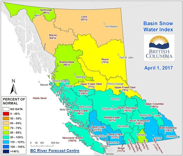
According to the B.C. River Forecast Centre, below-normal snowpack is present in the Upper Fraser West basin, which includes the communities of Burns Lake, Fort St. James and Vanderhoof.
Near-normal levels range from 90 to 110 per cent. With snowpack at 71 per cent of normal in the Burns Lake area, there’s an increased risk of low flows, which can be lethal to fish.
However, snowpack levels are not enough to determine low summer flows.
“Snowpack is just one of the elements that determine whether or not extreme conditions will emerge,” explained Greig Bethel, a spokesperson for the Ministry of Forests, Lands and Natural Resource Operations. “Weather, through the remaining portion of the snow accumulation season, the melt season and into the summer, is also a key driver on whether or not low streamflows will occur.”
March weather was dominated by prolonged periods of cool, particularly over northern B.C., where temperatures were up to 4 C below normal. In the northern half of the province, March precipitation tended to be closer to normal, or slightly below-normal.
Seasonal forecasts from Environment and Climate Change Canada indicate an increased likelihood of above-normal temperatures over the April-June period, particularly for northern B.C.
Neutral El Niño conditions are now present in the Pacific Ocean, and the Climate Prediction Centre at the U.S. National Weather Service/NOAA is forecasting that neutral conditions are favoured to persist through the spring of 2017, with increasing chances for El Niño - which brings warmer than normal temperatures - development into the fall period.
Provincially, snow basin indices trended closer to normal, with the provincial average for all April 1 snow measurements at 98 per cent of normal. Snow basin indices for April 1 range from a low of 62 per cent of normal in the Liard to a high of 123 per cent of normal in the Lower Fraser.
With two to four weeks remaining in the snow accumulation season, the River Forecast Centre says changes to the seasonal runoff outlook are possible, but at this stage would require extremely wet or cool conditions to make a significant impact on seasonal flood risk by either accumulating more snow, or delaying the melt season.
Although seasonal volume runoff forecasts are near normal for most basins across the province, flooding is always possible during the snow melt freshet season, even in years with normal or lower than normal snow packs.
The River Forecast Centre will continue to monitor snowpack conditions and will provide an updated seasonal flood risk forecast in the May 1 2017 bulletin, which is scheduled for release on May 8.