Snow basin assessments for late May and early June show below normal snowpacks for the Burns Lake and Houston regions, as warm weather has quickly melted snow across most parts of British Columbia.
“This year, low June 1st snowpack reflects melt that is 1-3 weeks ahead of normal for most areas. This is the result of an early start of the melt season at low elevations from warm weather in late March, and generally lower than normal seasonal snow accumulations,” said the River Forecast Centre in its Snow Survey and Water Supply Bulletin on June 7.
READ MORE: Warm weather causing historically low snowpack
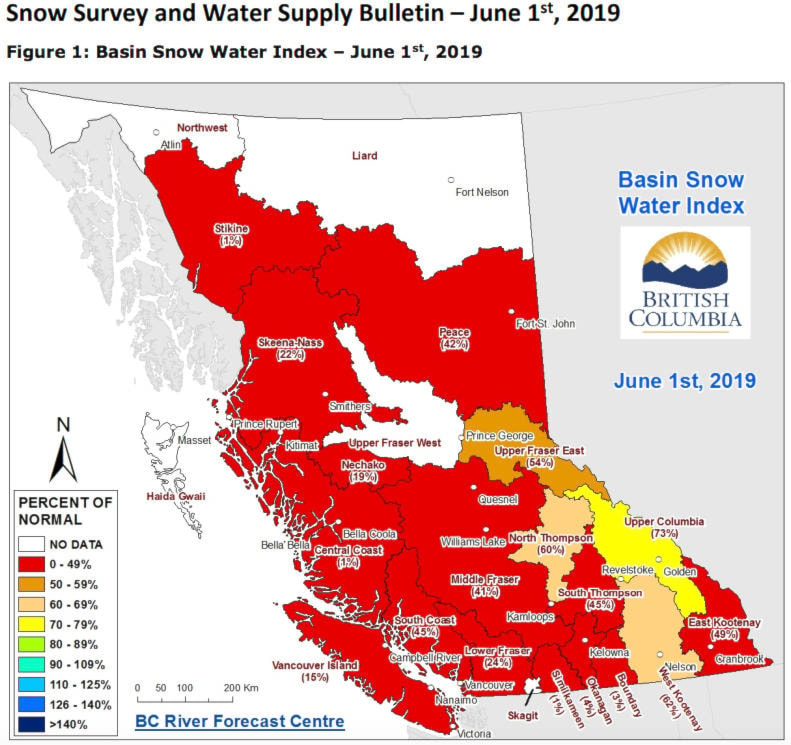
There was no data for the snow basin index for the Upper Fraser West basin, which includes Burns Lake, Fort St. James and Vanderhoof. But Dave Campbell, head of the BC River Forecast Centre told Lakes District News that the basin has experienced similarly low snowpacks and high snowmelt of neighbouring basins, and the level would be in the 20 per cent of normal range.
It was at 61 per cent of normal on May 15; and at 21 per cent of normal on June 1, 2018, much lower than the 120 per cent of normal level in 2017.
For 2015-2016 the readings were lumped in with the Upper Fraser East basin, making the June 1 level lower than 46 per cent of normal in 2015, but higher than the 5 per cent of normal in 2016.
The neighbouring Skeena-Nass basin – comprising Houston, Smithers and Terrace – is at 22 per cent of the normal level, and was at 56 per cent on May 15.
The Nechako basin - to the south - was at 19 per cent. It was at 52 per cent of normal on May 15.
The levels for the Nechako and Skeena-Nass basins are among the lowest since 2013.
The early melt saw 55-100 per cent of the snowpack melt across most sites. Mid-elevation areas are now snow-free.
Though that means the flood risks are now minimal, streamflows are low and there is more susceptibility to drought, Campbell said.
“We’ve really seen [streamflows] dropping off over the last week or so,” in the Upper Fraser West basin. “We’re transitioning into lower than normal flow this year. The smaller tributary creeks are below normal.”
Low flows are expected into the summer, the report said.
Wet weather over the past week changed what had been the recent dry spell, which makes fuels drier and contributes to wildfire risks.
Higher temperatures are expected to continue, with Environment and Climate Change Canada forecasting above normal summer temperatures for June-August across B.C.
Most of the province, including the northern Interior is classified as “dry” (Level 2) by the B.C. Drought Information Portal. Only three regions - Upper and Lower Columbia and West Kootenay in the southeast - are “normal.” The East and West Vancouver Island and Fort Nelson regions are “very dry.”
Blair McBride
Multimedia reporter
Send Blair an email
Like Lakes District News on Facebook