The snowpack assessments for Mid-May concluded and the results suggest above normal levels for northwestern British Columbia and the Burns Lake region.
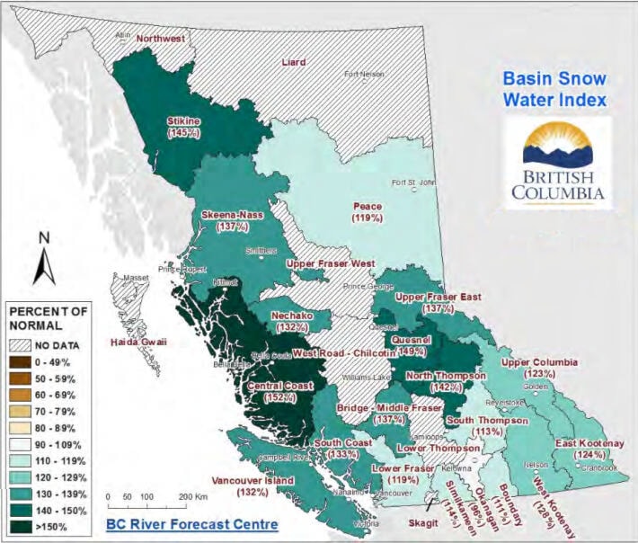
The Upper Fraser West basin, which includes Burns Lake, Fort St. James and Vanderhoof, had a snowpack level of 140 per cent of normal on May 1 as per the data from the BC River Forecast Centre. While there were no SWE measurements recorded for the Upper Fraser West for May 15, the automated snow weather station 1A12P Kaza Lake is still reporting snow depth and the May 15 measurement was the highest snow level since the station became active in 2016.
The neighbouring basin of Nechako – in areas including Tahtsa Lake, Skins Lake and Mount Pondosy – is at 132 per cent of the normal snowpack level. It was at 104 per cent of normal at the beginning of May.
The Skeena-Nass basin – northwest of Burns Lake and comprising Houston, Smithers and Terrace – is at 137 per cent, slightly up from 109 per cent in March.
Snow pack throughout the province ranges from 96 to 152 per cent of normal. The provincial average for all snow measurements across the province is 128 per cent of normal, and the Fraser River is 129 per cent.
The June 2 snow conditions commentary included a temperature update for May. According to the commentary, temperatures in May were below normal throughout the province, ranging from an average of -0.5 to -3.0 C below normal. Prince George Airport measured the fourth coldest and third wettest May on record since 1943, while Fort St John measured the seventh coldest and second wettest May on record since 1942. Such cooler temperatures have significantly delayed this year’s snowmelt.
The combination of an above normal May 15 snow pack, cool weather through April and early May, continued snow accumulation, and short-term weather forecasts that predict seasonal to cool conditions for the province, basically mean that the risk of spring flooding has also increased.
While snow pack is only one factor related to freshet flood risk, weather conditions through May, June and July will determine the timing, magnitude, and rate of snowmelt, and heavy rainfall events can worsen the situation. The greatest risk will occur if a significant province-wide heat wave occurs for a longer period over the upcoming six to eight weeks.
The next snow bulletin will be released on June 8 and will contain the most up-to-date snow basin indices.