Snow packs are one of the major factors for flood risks in the province however, snow packs alone cannot determine the flood risks. Things like the spring weather or amount of rainfall, are the other determining factors and this year, according to the River Forecast Centre, the flood risks due to snow packs for the Upper Fraser West area that includes Burns Lake, are not high.
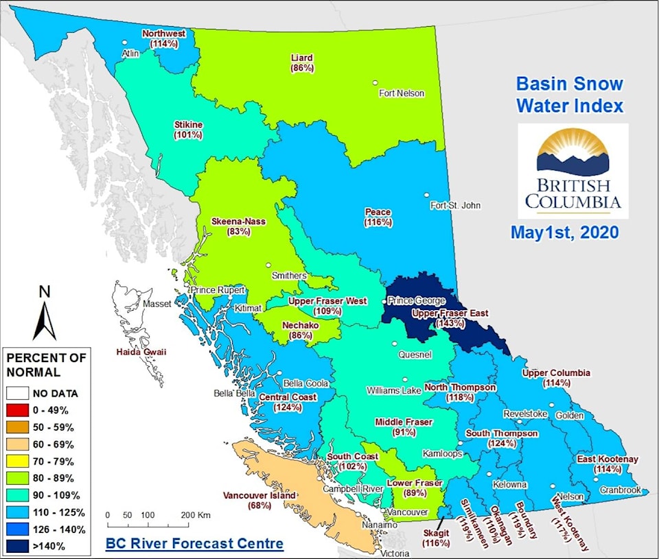
The snow basin index for the Upper Fraser West basin, which includes Burns Lake, Fort St. James and Vanderhoof is at 109 per cent of the normal level as per the May 1 data released by the BC River Forecast Centre.
“Most of the rivers through the region have hit their peak or are kind of at the peak for the year right now. Fraser Lake, Nautley river, and gauges in Burns Lake over to Houston, they have all reached a peak or are near peak, over the last week; they are still high, but I think we should start to see those drop over the next week or two,” said Dave Campbell, head of BC River Forecast Centre.
The Nechako basin which borders Upper Fraser West, comprising of Tahtsa Lake, Skins Lake and Mount Pondosy, is at 86 per cent of the normal snow pack level and the Skeena-Nass basin which is to the northwest of Burns Lake and includes Houston, Smithers and Terrace, is at 83 per cent of the normal level.
According to the snow survey and water supply bulletin released by the BC River Forecast Centre, “Typically, the provincial snow pack reaches its maximum level in mid-April. Significant increases to the current snow pack are thus not expected.”
Therefore, the current risk of flooding due to snow melts, based on these indices is very low according to Campbell but he added that “we will see that risk decline in the coming week or two, barring any heavy rainfall that we get in the next couple of weeks when the risks are most.” He also added that the current weather conditions weren’t particularly concerning as they were not seeing that kind of heavy-rainfall pattern of weather develop in the next two weeks.
According to the Environment and Climate Change Canada data, April was the second consecutive month of cooler and drier than normal conditions across the province and saw below normal precipitation in most areas of the province. However, a short spell of warm weather in late April, early May, caused the mid-elevation snow to start melting quickly.
Campbell informed that despite the snow packs being above normal for this year, the low elevation snow melt started early and the mid-elevation snow is coming off now. He noted that these staggered snow melts have helped in maintaining the water levels. “It seems this year has been quite patchy—so some areas had a lot of snow but the nearby regions didn’t seem to have gotten a lot of snow. There is quite a lot of variability and it didn’t seem as if the snow was high everywhere, so that might be playing a role in the snow pack not being as widespread,” Campbell explained.
The River Forecast Centre is now looking at rivers on a day-to-day basis and an updated flood risks forecast will be released on May 21.