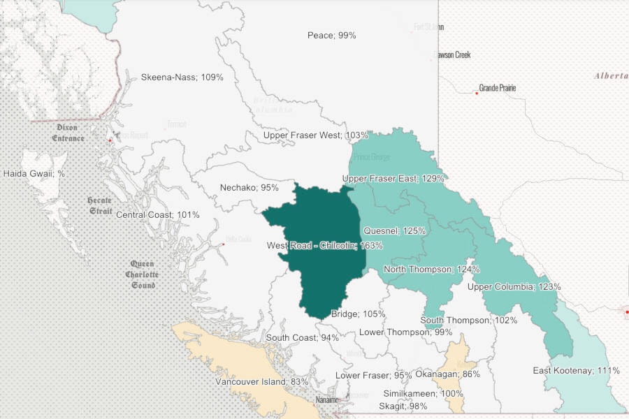
As of March 1, statistics from the B.C. government website indicate that normal snowpacks were measured for Nechako, Skeena-Nass and the Upper Fraser West. This means that they all measured between 90 and 110 per cent of normal snow pack.
All three basins measured significantly lower than on March 1, 2021. Nechako measured at 95 per cent of normal compared to 117 per cent last year, Upper Fraser West measured at 103 per cent compared to 109 per cent last year and Skeena-Nass measured at 109 per cent compared to 114 per cent last year.
The website indicates that the average of all snow measurements for the entire Fraser River basin is at 107 per cent of normal, decreasing slightly from 108 per cent on Feb. 1. By early March, nearly 80 per cent of the annual B.C. snowpack has typically accumulated. Snowpack throughout the province ranges from 83 to 129 per cent of normal as of March 1.
Despite normal statistics for the region, the government stated in their report that every region is at risk for flooding, even if the snowpack is slightly below normal.
READ MORE: Snowpack above normal for Burns Lake region
The weather conditions during spring play a critical role in the rate at which the snow melts. For example, a gradual warming under dry conditions is ideal to lessen the flood risk. A lengthy cold period with high amounts of precipitation followed by a sudden extreme heat wave could lead to flooding.
According to Brett Anderson, AccuWeather senior meteorologist, below normal temperatures and slightly below normal precipitation should be expected in the Burns Lake and Houston area, meaning it will be colder and slightly drier compared to normal.
READ MORE: Upcoming weather outlook in Burns Lake
“I expect above normal snowfall for the rest of March and April. Average snowfall until May combined in your area is about 30 cm, so I would say expect 40 to 50 cm. I believe temperatures will trend colder than normal for the rest of March and the first half of April. Expect days close to +5 into early April,” Anderson told Lakes District News.
Have a story tip? Email:
Eddie Huband
Multimedia Reporter
eddie.huband@ldnews.net
Like us on Facebook and follow us on Twitter.