Floodwater has washed away an entire section of road amid overflows in the Lakes District, after hot weather hit the high snowpack to create an unusually intense spring freshet.
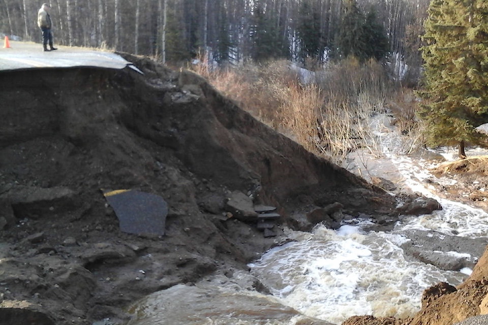
Photos submitted by Southside resident Nancy Plesko showed that a section of Ootsa Nadina Road was destroyed by a torrent of water, leaving a wide chasm several metres deep.
READ MORE: Workers building detour around washed-out road
Overflows covered large sections of the road bordering the north shore of Ootsa Lake over the weekend of April 28-29, including the area around Ootsa Lake Bible Camp.
A reader also commented on Facebook that flooding occurred on the northern shore of Francois Lake.
Lakes District Maintenance, the company in charge of highway maintenance in the region, didn’t immediately reply to a request for comment from the Lakes District News.
Saul Creek stabilized
Meanwhile, conditions stabilized at Saul Creek after the Village of Burns Lake opened a level-one emergency centre to deal with flooding that created a pool of water along Railway Avenue.
Floodwater subsided after workers built a containment berm at the south-west end of Saul Creek, which runs between the playing fields behind Lakes District Secondary School and Burns Lake Band.
Workers also removed a footbridge that normally crosses the stream of water between the fields.
The embankment appeared to keep the fast-moving stream in check, and water levels had fallen by 15-30 cm by Saturday, April 28, according to the village.
Flooding also forced the village to close the south end of Rod Reid trail on Friday, while fast-moving waters prompted the village to close the Eveneshen Nature Trail.
Sheryl Worthing, the chief administrative officer for the village and director of the emergency operations centre, said the village was continuing to monitor the situation.
Regional district issues advisory
The Regional District of Bulkley-Nechako (RDBN) issued a statement on April 27 advising residents to prepare for an increased risk of flooding.
The statement said that situation updates would be posted on the RDBN’s emergency information page on Facebook and the RDBN’s website. It also urged residents to monitor the website of the B.C. River Forecast Centre for up-to-date river advisories.
People living in areas vulnerable to flooding should prepare an emergency kit for each family member with enough supplies for a week, move flood-prone property to higher ground and monitor local media, the RDBN statement said.
The RDBN also recommended that residents watch out for erosion and unstable banks, and to be cautious around fast-flowing bodies of water. Plans should also be made for pets and livestock, the statement said.
Earlier in the week, the regional district indicated that it was ready with sandbags if flooding poses a risk to homes.
“The RDBN have sandbags available in a number of locations across the region which can be distributed to residents along with sand in the event of an imminent risk of flooding to a dwelling,” said RDBN planning director Jason Llewellyn, in an email to the Lakes District News.
Sudden melt
The abrupt change in weather is also source of concern for the lumber industry. Hampton Lumber CEO Steve Zika said the company is keeping an eye on areas of concern, where logging roads and bridges could wash out.
“We have an inventory of our areas that we are concerned about and we are monitoring these areas on a daily basis to ensure we don’t end up with road failures or washouts,” said Zika in an April 25 email.
“In the event that we start seeing things that we are concerned about, we have maintenance crews that are ready to go out and remain in areas as needed.”
David Campbell, head of the provincial River Forecast Centre, said on April 23 that the Bulkley and Nechako rivers weren’t a source of concern, but that smaller tributaries could rise with the sudden onset of the spring freshet in areas with high snowpack.
“We haven’t really seen melt yet there significantly,” he said. “I think this will notch those areas up a bit.”
High snowpack, hot weather
By the beginning of April, the snow-water equivalent — a common measure of snowpack levels — stood at 204 mm in Burns Lake, compared to an average of 119 mm between 1981 and 2010. That means the snowpack was 171 per cent the historical norm.
That high snowpack combined with temperatures around 20 C to create flooding conditions in the Lakes District. At the time of writing, temperatures are forecasted to reach 22 C by Saturday, May 6.