Our guiding area covered hundreds of square miles of wetlands and meadows, rivers and lakes. My Dad was noted for his migratory bird hunting, in which we were all involved. The territory was huge and hundreds of thousands of geese and ducks nested and migrated through our area, every year. Dad’s houseboat was used for this for over 40 years. We lost everything in 1952, when the flooding began…and his houseboat was crushed by the ice and the rising flood waters that first winter.
The marshes and wetlands along the shores were also breeding grounds for thousands of moose and other animals; the water rose over 150 feet through those wetlands.
Over the next couple of years, as the flood waters continued to rise, the devastation continued to get worse. Caribou, moose, bears and other animals, were drowned trying to cross the lake on their seasonal migratory routes. Winter feeding grounds were flooded and destroyed. Mud, fallen trees, and miles of water-soaked debris; including the rotting carcasses of animals, completely covered the edges of the flooded shorelines.
Our only source of water, and everyone else’s, came from the lake - from which we hauled 45-gallon drums full for household use, every day. During the flood, it was often impossible to get to the water, for the debris floating along the edges. When we were able to haul water, we had to add bleach to kill the tiny bugs, that floated by the millions. The water had to sit to allow it to clear and the mud to settle to the bottom.
Over the next few years, the flood waters slowly but surely destroyed everything below the 2800 elevation mark. Ootsa Lake was raised 149 feet, spreading for miles out along every shore. Everything was taken by the flood.
Nothing was cleared prior to the flooding…the water took everything: barns, barnyards, outhouses, graveyards, gardens, and miles and miles of fences.
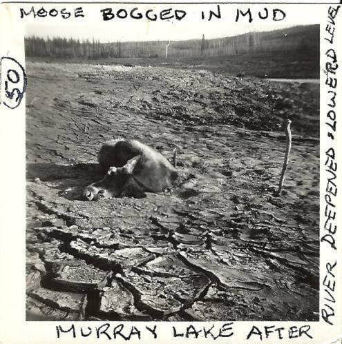
The moose were probably the worst affected, as they would swim the lake in the fall to get to their winter-feeding grounds and return in the spring. Many thousands of moose drowned as the windfalls floated to the surface in among the standing trees along the shoreline, so made it impossible for swimming animals, as well as our boats, to get ashore.
My brother Jim and myself would take a river pole and puncture the bloated stomach of drowned moose, so they would sink…they would drift for weeks otherwise.
The bodies would float ashore and pollute the waters, they were the worst where we were getting our drinking water. We would have to tow them out from shore and sink them out in deeper water.
Our portage to Big Eutsuk Lake was totally impossible to use for all the years that the lake was rising. The trees floated up and uprooted, blocking access to the shore. The trees that had anchored the rail tracks of the portage had uprooted as well, floating up and twisting the rails. So, our hunting area was not only devastated forever, but it was also years before we could get over the portage to the only lake that was not destroyed by the floods, Eutsuk Lake.
As the water rose, there were dams contracted to stop the water from flowing into Cheslatta Lake…so earth dams were constructed at Bear Lake, Skins Lake, and on our property on Ootsa Lake. This became the site of the Spillway.
The spillway was another devastating blow. The gates were opened when the water rose too high in the lake (reservoir), letting the excess water out to cut its own path down to meet the Nechako River, nearly 40 miles away through the virgin timber and the lakes and marshes.
Billions of cubic yards of earth were cut away, sending the soil and trees down to wherever they would hang up. The water was so thick with mud that it snapped like chocolate pudding and was actually thick. There was not even a creek on our place, so what you see below the spillway today used to be pine forest, like the remaining forest on the sides of the river now below the spillway.
The banks, below the spillway, are cut 100 feet high and 300 feet wide, by the water. In the first few years, the silt would spread out and the water would cut a channel around the silt bed, leaving a deadly trap for animals trying to get to the water. Moose, horses and cows would sink and die in the muddy traps.