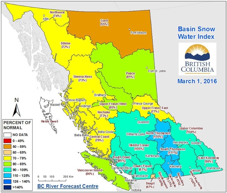
According to the B.C. River Forecast Centre (BCRFC), lower than normal snow packs in the Nechako/Upper Fraser West basins indicate potential for low flows in the late spring and summer.
Near-normal snow packs range from 90 to 110 per cent.
The Upper Fraser West basin, which includes the communities of Burns Lake, Fort St. James and Vanderhoof, is at 85 per cent of normal while the Nechako snow packs are at 73 per cent of normal for this time of year.
However, according to Greig Bethel, a Spokesperson with the Ministry of Forests, Lands and Natural Resource Operations, the lower than normal snow packs seen in Northern B.C. are not enough to determine spring flood risk or summer flows.
"Snow pack is just one of the elements that determine whether or not extreme conditions will emerge," explained Bethel. "Weather, through the remaining portion of the snow accumulation season, the melt season and into the summer, is also a key driver on whether or not low streamflows will occur."
"It is too early to tell what effect the current snow pack will have on streamflows this season," he added.
Seasonal forecasts from Environment Canada are indicating a high likelihood of above-normal temperatures across British Columbia over the March to May period, with temperatures in Northern B.C. ranging from 2 C to 3 C above average.
In addition, Environment Canada says it is likely that the warmer than normal temperatures will extend through the summer months in Northern B.C.
British Columbia experiences warmer than normal temperatures during El Niño. According to BCRFC, strong El Niño conditions peaked earlier in the winter and are expected to continue to decline into the spring.
The forecast of warmer weather through the spring, combined with warm temperatures already experienced this winter, is likely to be an important factor in this year’s freshet season, according to BCRFC.
With the advanced melt of some low to mid-elevation snow that has already occurred, continued warmer than normal temperatures would bring an earlier shift in the timing of the rise, peak and recession to summer flows of this year’s freshet.
According to BCRFC, flooding is always possible during the snow melt freshet season, even in years with normal or lower than normal snow packs.
The BCRFC will continue to monitor snow pack conditions and will provide an updated seasonal flood risk and stream flow forecast next month.