“Recreation” might sound like all fun and games, but managing a forest with that aim is anything but. It requires a lot of careful planning, balancing of values and hard work.
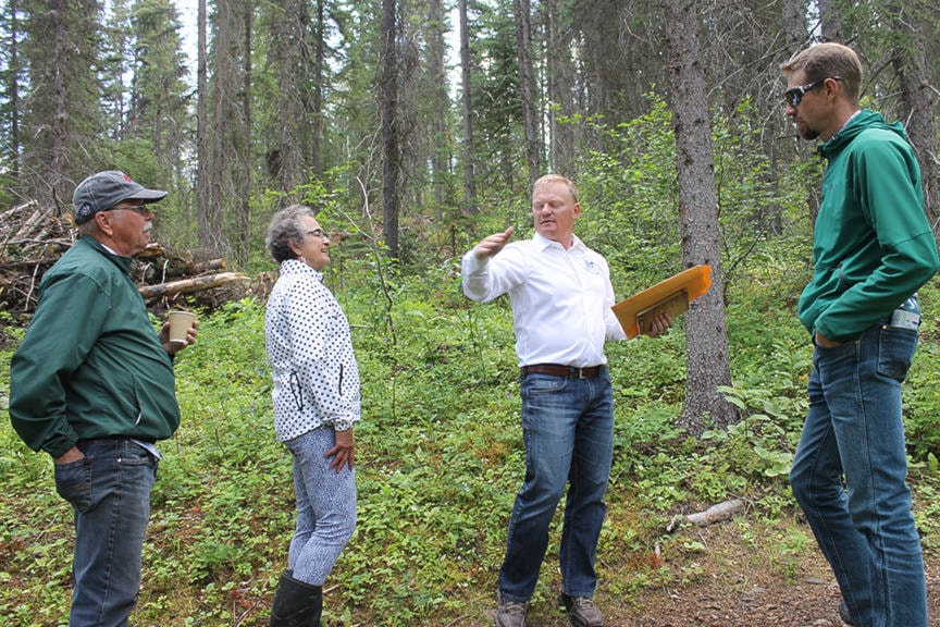
“A working forest is an area where we manage for all the social and environmental and economic values. In this area our intent is to manage for the recreational values,” said Frank Varga, General Manager of the Burns Lake Community Forest (BLCF), during a public tour near Kager Lake on June 26.
That area - including Boer Mountain - is part the BLCF’s Kager Recreation Area Polygon (forestry management unit) and comprises about 2,849 hectares. Of that, the project area proposed for activities is 1,300 ha and 174 ha was slated for harvesting.
The purpose of the project was to reduce the fire hazards in the area where one of the main users is the Burns Lake Mountain Biking Association (BLMBA) and to start the process of protecting infrastructure on Boer Mountain, including the valuable radio tower.
READ MORE: Logging on Boer Mountain
“And in doing so generate a social and economic value by putting our community members to work,” Varga said.
One of the starting points of management is mapping and Varga showed a map of the forest around Kager Lake. BLCF used drones to take high resolution photographs of the forest and identify stands of aspen, live trees and stands that were killed by mountain pine beetle.
The BLCF made harvesting decisions based on what the photography compositions showed.
“If it was greater than 50 per cent green we would have partial harvesting. There were other areas that we delineated that would be clear cut. That was because the composition was greater than 50 per cent dead…the extent of the morality rate is very high.”
But whether the stands were more than half green or half dead, the other half would be left alone.
“Any stand in this ecosystem - if you remove more than 55 per cent, 60 per cent, because of how they’re formed they can’t withstand being opened up that much because they would start blowing over. We have to be very careful in finding that fine balance and fine line,” Varga said.
In collaboration with the BLMBA, some roads previously used for harvesting and hauling have been deactivated and rehabilitated. “They didn’t want to create a whole bunch of access roads,” said Varga, referring to the complications of mountain bikers and motocrossers using the same roads.
“[They] become sort of a wilderness road and we manage for water [and] siltation, but we create enough access that we can get in there in the future if we have to.”
Some roads were completely deactivated and others were left for safety access to bike trails.
As he took the tour members into the forest not far from the new campground extension, Varga pointed out the dead material, branches and some blowdown, much of it the result of pine beetle infestation.
Even though fire is how the forest ecosystem in this area regenerates itself, that particular portion hasn’t experienced fire in almost a century, Varga said.
“These forests tend to have that 100-120 year fire return interval.”
He then explained, half-seriously that he has been proposing to some people holding a “Burnfest” - comparable to Germany’s Oktoberfest - in a few months.
“We’ll set up a booth in the parking lot and for $5 people can come out - obviously supervised - and they can light some piles with a drip torch. And the $5 will go towards the BLMBA for maintaining trails or whatever. Everyone has got a little pyro in them, right?” he asked with a laugh.
“The more people who get involved in the activity the more they’ll appreciate what was done to manage for these values. It is very, very difficult to balance all those values.”
A large part of management is hazard reduction, or hazard abatement and one example of that in the Kager Lake forest is the construction of a shaded fuel break.
After an opening is created in the forest by a partial harvest, the branches or dead trees that could fall down or hang from other trees are cleaned up, and the finer fuels on the ground are cleared away as well. The break reduces the chances a fire will spread along the ground and up into the crowns of the trees.
“[In that case] the green vegetation comes up very effectively, but there’s just enough darkness that it maintains the moisture of the forest floor more effectively than a clear cut,” Varga said.
BLCF’s shaded fuel break work has been aided by the $338,298 in hazard abatement funding from the Forest Enhancement Society of British Columbia (FESBC). The work also included hand and machine pilling.
Regulations from the BC Wildfire Service (BCWS) and provincial laws have called for reducing organic debris left over from harvesting. In some conversations Varga has had with BCWS personnel, they wanted debris to be reduced to under five tons for areas within 2 kilometres of a community.
“Most sites are around 60 tons naturally. Anywhere from 35-60 tons is what we see in these forests. And now to bring it down to five is very difficult. The five tons is probably unachievable from a forestry management stand point,” Varga said.
In his project proposal to the FESBC, he offered a target of 10 tons per hectare within 2 km of a community and 15 tons for 2-5 km from a community. He also added to the proposal the possibility for shaded fuel breaks, and managed to reach an agreement with BCWS that getting the fuel down to less than 10 tons per ha was enough of a reduction to manage for fuel hazards.
But some dead fuel should be left behind, because another value the BLCF aims to satisfy is wildlife habitat.
“We’re also trying to ensure that we support some of the little critter activity. The pine marten or the squirrels or the birds. All of those animals also need a certain amount of dead in the forest. It can’t all be just live, green trees. It has to be a combination of things.”
The BLCF was incorporated in 1998 and covers more than 92,000 ha. Its boundaries stretch from Maxan Lake in the west to Endako in the east, and from Pinkut Lake in the north to Francois Lake in the south.
Blair McBride
Multimedia reporter
Send Blair an email
Like Lakes District News on Facebook