A high-tech study terrain study is about to happen between Burns Lake and Tchesinkut Lake.
The study will be used, if all goes according to Regional District of Bulkley-Nechako (RDBN) plan, to design a trail between the two communities along Highway 35, and also flip the data over to the provincial government for their use on future development. The Ministry of Transportation and Infrastructure (MOTI) has agreed to help fund the study.
The RDBN put out a request for proposals in January through the BC Bid public contracts system. After reviewing four proposals, WSP Canada was the successful engineering proponent, at a cost of just under $76,000.
“The purpose of the study is to outline technically feasible conceptual alignment options for a multi-use trail connecting the Village of Burns Lake and Tchesinkut Lake (approximately 12 km),” said the Regional District’s director of planning, Jason Llewellyn.
The project received a $50,000 grant from Infrastructure Canada’s Active Transportation Fund. The remainder of the costs are covered by the Northern Capital Planning Grant.
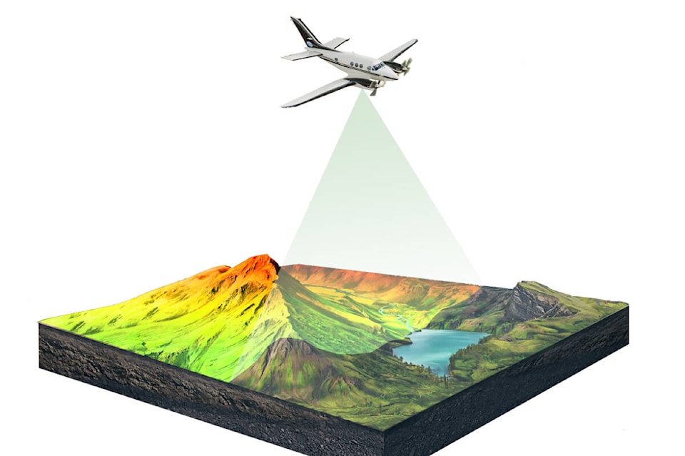
The WSP Canada proposition includes a partnership with MOTI to undertake a special survey method called LiDAR (Light Detection And Ranging) which is a uses remote sensing technology that produces high resolution three-dimensional imaging “which will be of value at the detailed design stage,” said Llewellyn. “The proposal is that the RDBN cover the cost of obtaining the LiDAR data ($21,259) and that the data be sold by the RDBN to the Ministry for their future use ($10,629).”
According to the U.S. Geological Survey, LiDAR is “a technology used to create high-resolution models of ground elevation with a vertical accuracy of 10 centimeters (4 inches). LiDAR equipment (is typically mounted) on a small aircraft. The laser scanner transmits brief pulses of light to the ground surface. Those pulses are reflected or scattered back and their travel time is used to calculate the distance between the laser scanner and the ground.”
“This highly detailed data can enable advanced analyses in areas such as flood mapping, forest inventories, urban infrastructure management, and beyond,” said Natural Resources Canada.
Burns Lake mayor Henry Wiebe was incredulous about the amounts being discussed.
“I did some investigating of my own on the cost of LiDAR and from my research, the LiDAR portion is probably only worth $8,000-$10,000,” said Wiebe.
Llewellyn agreed in principal but added that “the cost of LiDAR varies greatly depending on the resolution, the quality, and the details. We have run these numbers and had discussions on these numbers with the Ministry of Transportation, and it’s in line with their expected costs for this type of resolution and type of LiDAR and they have committed in writing to cover this portion of these costs. It’s a bit of a test case for them, but they say ultimately, sooner or later along the Highway 35 corridor, they are going to need that detail of LiDAR for designing projects and highway improvements.”
On the promise that RDBN staff will not move forward on the trail design study until the necessary agreement regarding LiDAR costs has been confirmed with the
Ministry, the Regional District board of directors voted in favour of proceeding with the plan.