Snow basin assessments for mid to late May show lower than normal levels for the Burns Lake and Houston regions, in line with generally drier conditions across British Columbia.
“Along with 2015 and 2016, this year is amongst the lowest May 15 snowpacks that have been observed in BC over the past 40 years,” according to a May 15 report from the River Forecast Centre.
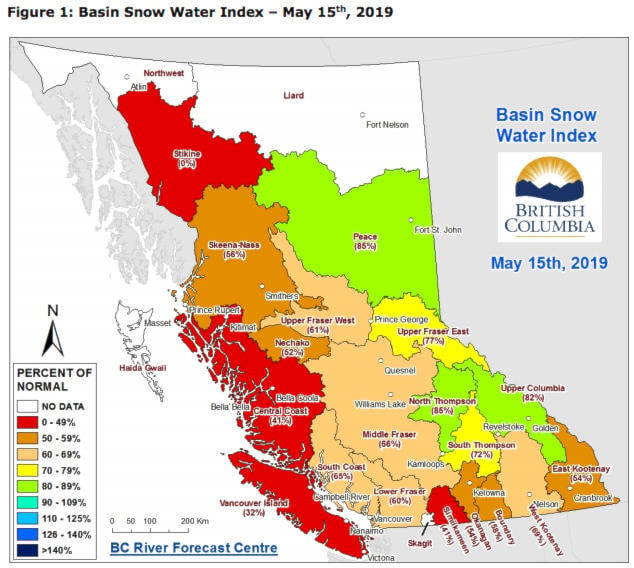
The snow basin index for the Upper Fraser West basin, which includes Burns Lake, Fort St. James and Vanderhoof was recorded at 61 per cent of normal on May 15.
A level of under 65 per cent is regarded as “well below normal.”
At the start of the month the same measurement was at 98 per cent of normal, according to the May 1 report, with warmer weather being a key main factor in the reduction.
The measurement follows a similarly lower than normal level in mid-April.
LOOK BACK: Snowpack level decreases for Burns Lake area
The neighbouring Skeena-Nass basin – northwest of Burns Lake and comprising Houston, Smithers and Terrace – is at 56 per cent, and was at 75 per cent on May 1.
The Nechako basin was even lower - at 52 per cent of normal - for May 15, and was at 72 per cent on May 1.
“By mid-May generally 15-25 per cent of the accumulated snowpack has melted. Early melt this season has meant that most sites have melted between 50-60 per cent of their snowpack as of current conditions.”
The lower snowpacks have reduced the risk of floods this season, however they’ve increased the possibility of low river flow conditions across B.C.
It wasn’t yet clear how the relatively drier conditions would contribute to possible wildfire risks in the coming months, as Dave Campbell, head of the BC River Forecast Centre explained to Lakes District News.
“It comes down to the weather and the fuel and moisture. When it melts, on the drought side of things we get that influence from the snow ending earlier.”
This May 15 represents a lower snowmelt level than the previous years.
For 2015-2018 the data for the Upper Fraser West and East basins was combined, making this year’s level of 61 per cent of normal lower than the 74 per cent of 2018, but higher than in 2016 when it was only at 23 per cent.
The Nechako basin snow index has steadily fallen since 2017 when it was at 127 per cent of normal. It was at 90 per cent of normal in 2018.
Skeena-Nass is also down. It was at 94 per cent of normal in 2018, but was much lower in 2016 when it was at 25 per cent.
Blair McBride
Multimedia reporter
Send Blair an email
Like Lakes District News on Facebook