After several days of above average temperatures, the Burns Lake area is returning to more seasonal temperatures this week.
On Oct. 24, the Burns Lake area experienced 26 mm of rainfall while Houston saw 28 mm - almost the total amount of rainfall usually seen in October in these areas. Meanwhile the Smithers area experienced almost 70 mm of rainfall, which resulted in the River Forecast Centre issuing a flood watch for the Bulkley River and tributaries.
According to Lisa West, a meteorologist with Environment Canada, November will bring cooler than average temperatures to the region. But beyond November, she says there’s no clear trend.
Although this fall and winter Environment Canada is expecting weak La Niña conditions, which bring cooler than average temperatures, West says it’s too soon to determine whether northern B.C. will be affected.
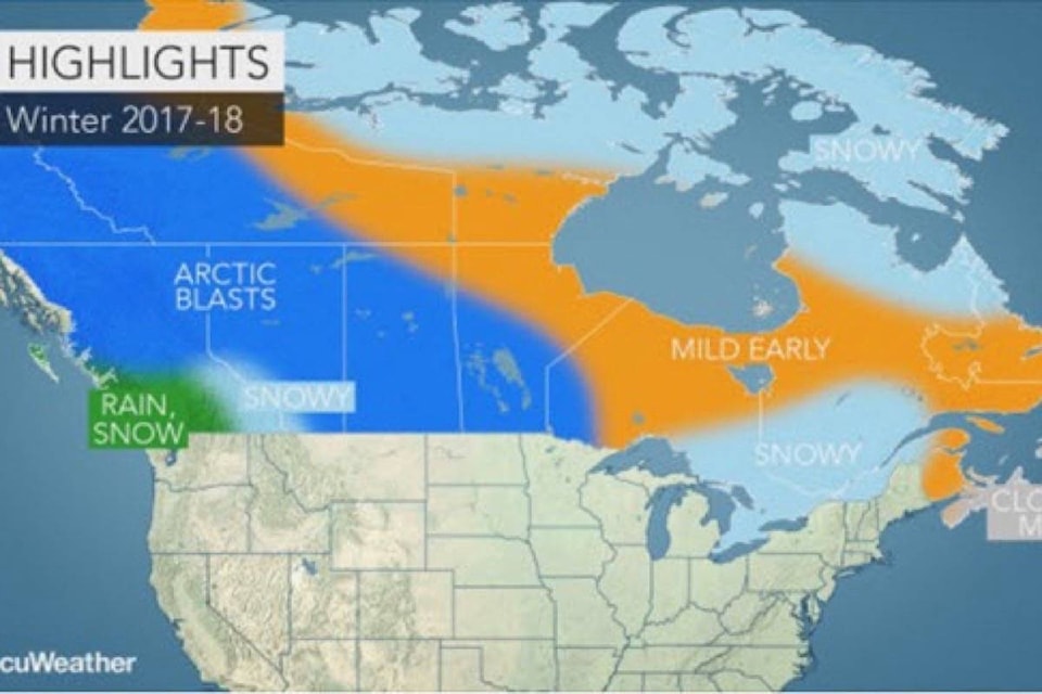
According to AccuWeather meteorologist Brett Anderson, the ski season in some parts of Western Canada is expected to get off to a good start with a quickly established snowpack.
“Although the heaviest snow will be confined to the Rocky Mountains, some snow is expected to make its way all the way to the coast of British Columbia, including around Vancouver and Victoria,” he said.
Drier-than-normal conditions are in the forecast for the rest of British Columbia, with only a few storm systems tracking far enough north to bring a significant amount of snow.
Meanwhile dangerously low temperatures are expected to grip the eastern Prairies. According to AccuWeather, waves of arctic air will blast across the Canadian Prairies in the coming months, causing temperatures to plummet to dangerously low levels multiple times throughout the winter. But winter is expected to start off on a mild note across the eastern Prairies before the bitter cold settles across the region.
“Compared to last winter, the upcoming winter is expected to be colder from the eastern Prairies to Quebec,” explained Anderson.
For much of Eastern Canada, a snowy winter is expected with the prospect of a few big snowstorms throughout the season.
“There are opportunities for several significant snow events from Windsor through Toronto and up into Ottawa and Montreal this winter, especially in January and February,” Anderson said. “The expected track of storm systems and the warmer-than-normal waters in the North Atlantic will help to keep the bitter cold of winter at bay.”
“This may also increase the potential for some major ocean storms during the winter that may target Newfoundland with rain or snow,” he added.
@flavio_nienow
newsroom@ldnews.net
Like us on Facebook and follow us on Twitter.